LLORET DE MAR · COSTA BRAVA
Fenals reveals a quieter side of Lloret de Mar: a beach shaped by Roman history, fishermen, a castle above the sea and November light between pines and rocks.
Today Fenals feels like a place made for stopping beside the Mediterranean.
Yet beneath that calm remain traces of Roman kilns, vanished fields, fishermen who read the coastline and a fortress that watched the horizon for centuries.
A few minutes from the centre of Lloret de Mar, Fenals opens into a broad bay between rocky headlands covered in Mediterranean vegetation. It is easy to see only sand, pines and water, but the place changes once its past comes into view. This same shore was a place of work in Roman times, a reference point for fishermen and an agricultural landscape long before tourism transformed the coast. I returned to it in November at sunrise, when the sun found a narrow opening between the rocks and, for a few moments, turned that ancient landscape into pure light.
01 · WHERE IT IS
Fenals, the other shore of Lloret de Mar
A Mediterranean bay separated from central Lloret by the headland of Castell de Sant Joan.
Fenals lies west of Lloret de Mar’s main beach on the Costa Brava. Around seven hundred metres long, it sits between rocky slopes that give the bay a more sheltered character than many visitors expect from one of Girona’s best-known seaside towns.
To the east, the land rises towards Castell de Sant Joan. To the west, the coast closes again between rock and vegetation before continuing towards Santa Clotilde and Sa Boadella. That contrast between open beach and rocky edges is why Fenals can offer very different scenes within a short walk.
02 · A NAME BORN FROM THE LANDSCAPE
Fenals had a name long before it became a famous beach
The place name appears to preserve the memory of a grass that once grew here.
Historian Joan Domènech i Moner records that Fenals took its name from a grass that grew in the area. It is a small detail, but it changes the way the place can be read: before hotels, apartments and promenades, its name was already tied to the land itself.
Traditional local place names also preserve references such as Punta de Fenals, Illa de Fenals and Sa Llosa de Fenals. They belong to a coast where rocks, points and profiles were useful markers as well as landscape.
03 · THE ROMAN SHORE
When Fenals was a place of kilns and pottery
Around two thousand years ago, this beach formed part of an industrial activity connected to the Mediterranean.
Archaeological work in Fenals uncovered a Roman settlement whose busiest period dates to the first century AD. Kilns and large structures were linked to the production and trade of pottery.
The beach itself probably mattered to that activity. Lloret’s Municipal Archive notes that Fenals may have made it easier to move pottery in and out by sea. The quiet water we associate with leisure was once part of a working Mediterranean route.
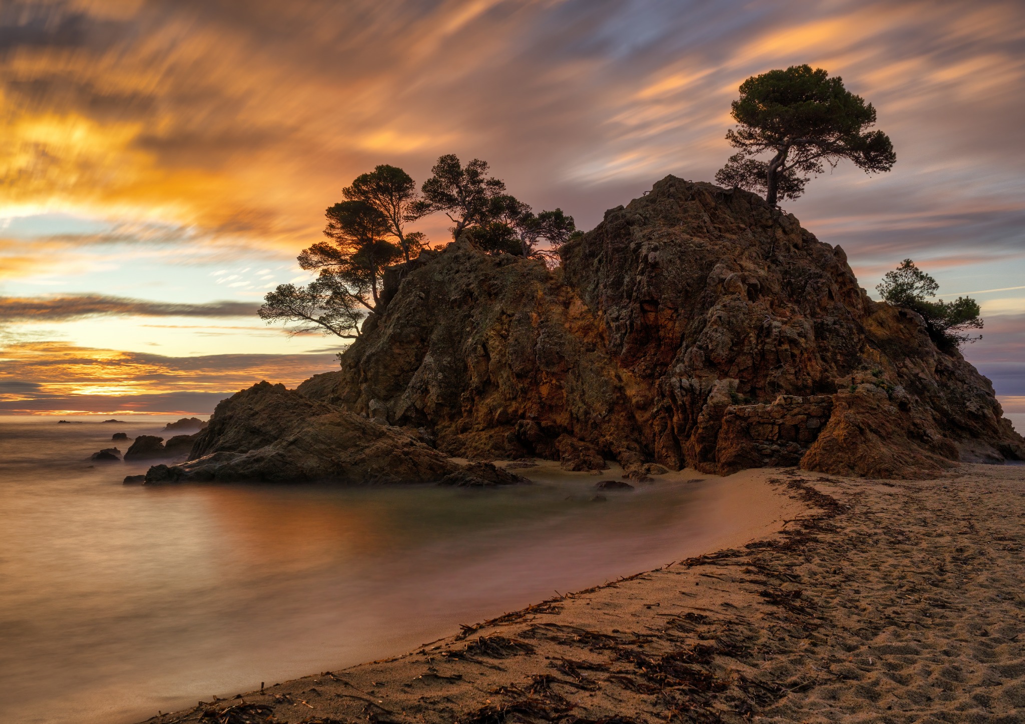
Rocky cove and Mediterranean pines · Lloret de Mar, Costa Brava · View photograph →
Another way to look at the beach
Where we now see umbrellas and open water, first-century Fenals held kilns, pottery and an activity that probably used the beach as a gateway to the sea.
04 · WATCHING THE HORIZON
The castle between Fenals and Lloret
Above the headland, Castell de Sant Joan recalls a coast that was not always watched in peace.
The castle stands on the height separating the beaches of Lloret and Fenals. Its origins go back to the early eleventh century, and for centuries it served as a defensive and lookout point over the coast.
It was attacked by a Genoese fleet in 1356, damaged by the earthquakes of 1427 and 1428 and later rebuilt. In 1805 a British naval attack struck the tower and part of the enclosure. Storms in 1840 and 1923 caused further damage. Today the restored tower still faces the sea, but no longer searches the horizon for hostile sails.
05 · READING THE COAST
How fishermen found their way before GPS
Mountains, houses and coastal profiles formed an invisible map for those who knew how to read it.
Lloret’s fishermen once used senyes: visual alignments that helped them locate fishing grounds from the sea. Two recognizable points in the landscape, one nearer the coast and another farther inland, could act like coordinates.
Fenals appears in those records. One documented senya used Montoriol and Ca l’Auba. For someone who knew the system, the shoreline stopped being a continuous silhouette and became a map made from hills, buildings and natural forms.
Photography begins with a similar act of attention: noticing how a rock meets the horizon, how a pine closes a frame or how a small opening may eventually catch the sun. The purpose is different, but the first gesture is the same — learning to read what is in front of you.
06 · THE FENALS THAT DISAPPEARED
Fields, gardens and summer visitors before the great change
Before tourism expanded, much of Fenals was cultivated land and the beach belonged to a far more rural landscape.
Old photographs and local memories show a Fenals that is difficult to recognize today: fields, vineyards, farmhouses and tracks crossing a much less developed landscape.
The transformation accelerated from the 1950s as hotels, bungalows and apartment blocks appeared and Fenals gradually joined the urban fabric of Lloret. Even so, traces remain, including the former bathing house of the Can Roviralta estate, now known as Casa del Mar, above the cliff.
07 · BEYOND THE BEACH
Pines and rock where the sand comes to an end
At the edges of Fenals, the landscape turns back into the rougher Mediterranean character of the Costa Brava.
Leave the most open part of the beach and the coastline quickly changes: irregular rock, pines leaning over the shore and small inlets that break the line of the sea. These quieter edges are where Fenals feels most intimate and where light begins to shape the landscape more dramatically.
08 · MY NOVEMBER SUNRISE
When the sun found a gap between the rocks
A brief alignment of light, rock and sea that only needed a few minutes of waiting.
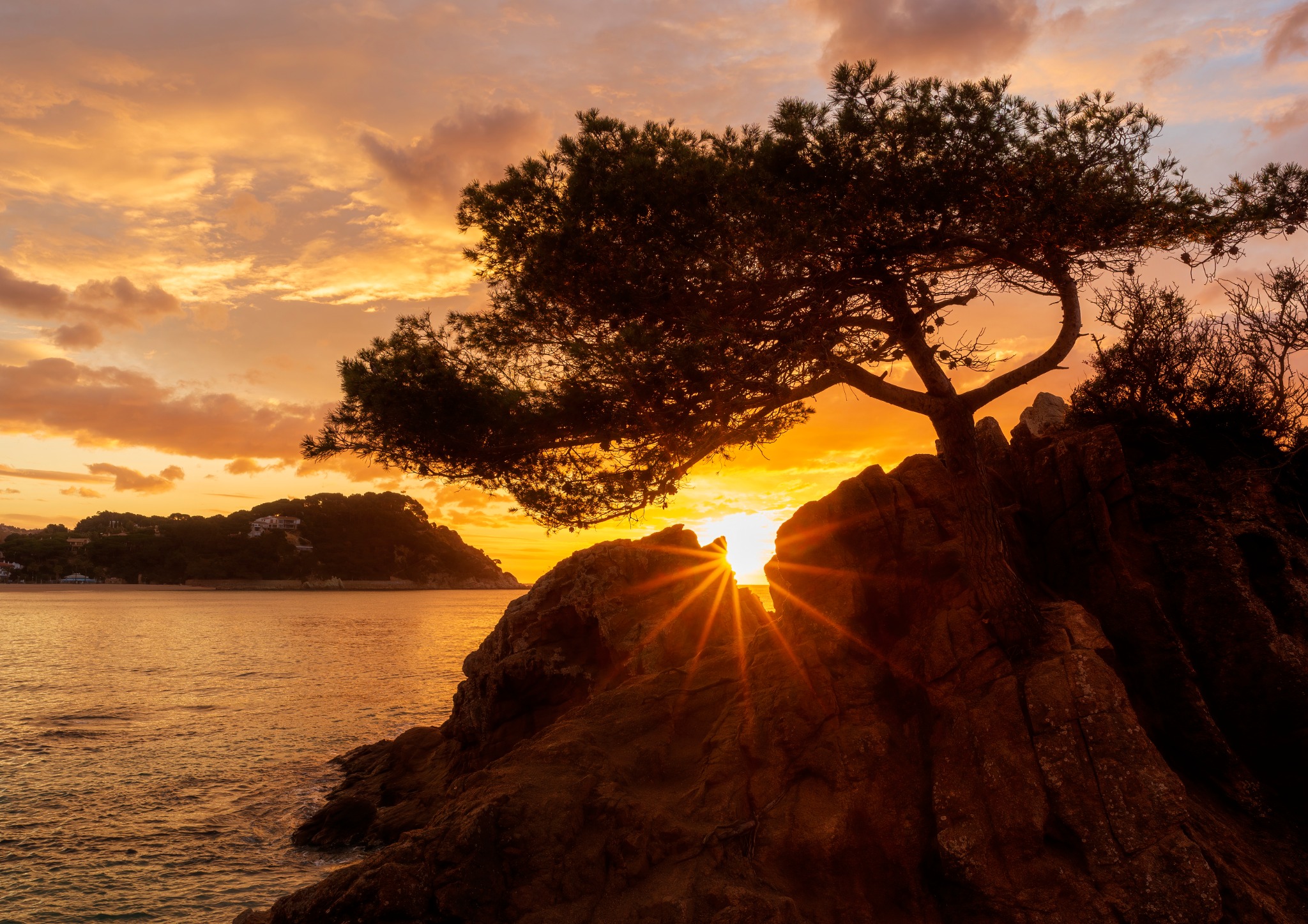
Golden light beneath the pines · Lloret de Mar, Costa Brava · View photograph →
I went to Fenals in November, when the sun follows a lower path and the first light can reach places that remain outside it at other times of year. On one rocky edge I found a composition dominated by a pine and dark masses of stone descending towards the Mediterranean.
Between the rocks was a narrow opening. As the sun rose, the light moved towards that gap until it sat exactly inside it. For a few moments, the brightest point in the whole landscape was enclosed by the rock itself.
It was not a monumental arch. That was part of what made it interesting: a small coincidence hidden inside the landscape, visible from one position and for only a short time. The pine stayed dark above the coast while the first light passed through the opening and reached the water.
Why November changed the scene
The sun’s position changes through the year. In November, its lower path made it possible for the sunrise to pass through this particular opening from the point where I was photographing.
FENALS AT A GLANCE
The essentials
Location: Lloret de Mar, La Selva, Costa Brava, Girona.
An unexpected history: a major Roman pottery site was active here in the first century AD.
An old way of navigating: fishermen used visual senyes to locate points at sea.
A moment I remember: the November sunrise sitting for a few moments inside a gap in the rocks.
Why Fenals deserves more than an afternoon at the beach
Fenals is easy to enjoy without knowing anything about its past. But the Roman kilns, the castle, the fishermen’s senyes and the vanished fields add depth to a landscape that at first seems simple. Different generations used, watched and read the same coast in different ways. Today we can walk it for quieter reasons, but rock, horizon and light remain its essential elements.
BRING THIS LIGHT HOME
Two photographs from the coast of Lloret de Mar
The two images in this article are part of my work on the Mediterranean coast. You can see each photograph in more detail here: